Fireguard Wildfire Tracker
- 4.4
- Rating
- 100.00K
- Installs
- Free
- Price

 Analysis by App-foxy
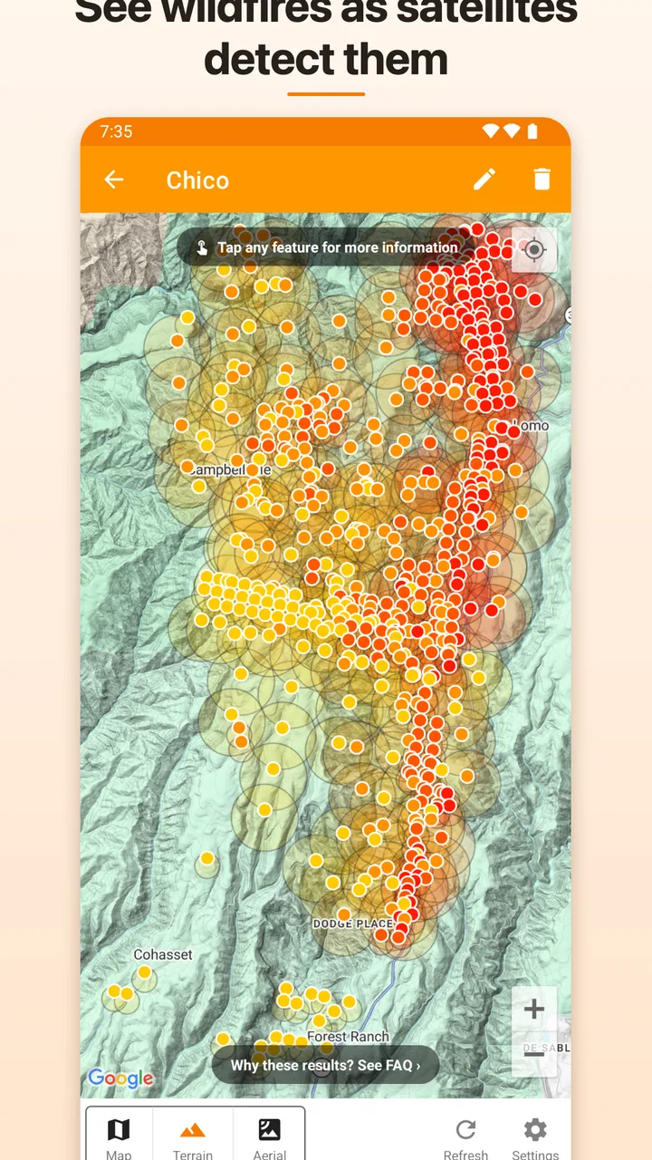
I approached Fireguard Wildfire Tracker as a practical weather app rather than another general forecast tool. Its focus is much narrower: helping people watch wildfire activity through NASA active fire data. That makes it interesting for anyone who lives near fire-prone areas, travels through large rural regions, or simply wants a clearer picture of where active fires are being detected around the world.
My first impression is that Fireguard is most useful when I treat it as an awareness tool, not an emergency authority. A map showing active fire detections can help me understand a developing situation, but it should not replace official evacuation instructions, local emergency alerts, or advice from fire services. That distinction matters because a satellite-based fire view and a street-level safety service answer different questions.
The app is free to install, is rated for Everyone, and comes from Qvyshift LLC. Its average rating is 4.4 from around 4.8 thousand ratings, with over 100 thousand installs. Those figures suggest a real audience for a focused wildfire tracker, while also leaving room for a balanced look at what it does well and where its limits become important.
You May Also Like

 Google Keep - Notes and lists
Google Keep’s Quiet Growth Shows the Appeal of Simpler Notes
As mobile work gets busier, Google Keep keeps winning a simple contest: capture a thought quickly, find it later, and get on with the day.

 Blood Strike: 2.5 Anniversary
Blood Strike’s Loadouts Turn Every Drop Into a Tactical Gamble
A close look at Blood Strike’s custom loadouts: how fast access to signature weapons reshapes its battle royale rhythm, rewards preparation, and narrows the gap between fights.

 Pandora - Music & Podcasts
Pandora’s Music Is Easy to Start, but Harder to Recover
Pandora’s strength is its low-effort path from a seed to a station. Its weak spot is how much confidence it asks you to place in connection, setup, and quiet recovery.

 8 Ball Pool
 Is Built on Rivalries, Rematches, and Routine
A close look at the rivalries, rematches, shared routines, and unanswered safety questions that turn a quick pool match into a persistent mobile community.

 Samsung Music
’s Quiet Strength Is Playing What You Already Own
Its reach comes less from spectacle than from dependable access to a personal library. That simplicity is both the app’s strongest retention engine and its ceiling.

 AccuWeather: Weather Radar
AccuWeather Review: A Quick, Clear Forecast for Everyday Decisions
For everyday plans, the best forecast is the one you can understand quickly. AccuWeather makes rain timing, radar, and local conditions easy to act on, with a few trade-offs.
More From Our News Desk



How Fireguard fits into real wildfire awareness
I find Fireguard most useful when I decide in advance what I’m trying to learn: whether a region deserves a closer check, not whether a particular place is safe. That distinction helps keep a broad satellite view in perspective and makes each visit more purposeful. Next, I’d consider how well that focused role holds up when I’m checking several places or returning to the app during a developing situation.
A focused view instead of a crowded forecast screen
Most weather apps try to cover everything: hourly temperatures, rain chances, wind, radar, warnings, air quality, and sometimes pollen or travel conditions. Fireguard takes a different route. Its central idea is to make global wildfire detection the reason to open the app. I appreciate that focus because it avoids forcing wildfire information into a general forecast interface where it can be easy to overlook.
The NASA active fire source is also an important part of the app’s identity. Satellite fire data can reveal activity across broad and remote areas, including places where a user may not have a nearby weather station or a convenient local news report. For a person checking conditions before a long drive, that wider view can be more useful than a normal forecast alone.
At the same time, a detected fire is not automatically a direct threat to a home, road, or neighborhood. Satellite observations have to be interpreted in context. A marker may represent a fire that is distant, controlled, short-lived, or unrelated to the route I am planning to take. I would therefore use Fireguard to decide what deserves closer attention, then verify the practical consequences elsewhere.
What the app is good at in everyday use
A realistic example is a weekend trip through a dry region. Before leaving, I could open Fireguard, inspect the broad area around the route, and look for clusters of active fire detections near towns, parks, or highways. If I saw activity close to the planned journey, I would not assume the road was closed. Instead, I would use that discovery as a prompt to check transportation notices, local fire agencies, and current conditions before setting out.
That workflow is one of the app’s strongest uses: it helps me ask better questions. Is there fire activity near the destination? Is the area worth monitoring more closely? Should I change the timing of the trip? A conventional weather app may tell me that the day will be hot and windy, but Fireguard draws attention to the fire activity itself.
It can also be useful for people who follow wildfire conditions outside their immediate neighborhood. Families with relatives in another region, outdoor enthusiasts, researchers, and travelers may value a global perspective. The app’s worldwide scope gives it a different role from a local emergency app that only covers one city or state.
Where the satellite view needs careful interpretation
The most important trade-off is precision versus context. NASA active fire data is valuable because it covers a large area, but a broad satellite detection does not provide the same detail as a local incident map. I would not expect Fireguard alone to tell me whether smoke is moving toward my street, whether a specific trail is open, or whether an evacuation zone has changed.
This is also why I would avoid treating the map as a live tactical display during an emergency. Fire behavior can change quickly, and the timing of satellite observations matters. A marker can be informative without being perfectly current for a fast-moving situation. If I were already under an official warning, my priority would be the instructions from authorities, not continued map checking.
That limitation does not make the app unhelpful. It simply defines its proper place. Fireguard is strongest as a discovery and monitoring layer. Local alerts, official incident pages, road information, and air-quality services remain better choices when I need immediate, location-specific decisions.
Trust begins with knowing what the app is for
For me, trust here is less about expecting one app to answer every question and more about understanding the boundary between detection and advice. Fireguard presents itself as a wildfire tracker built around NASA active fire data. That gives the app a clear purpose, but it does not turn every map point into a confirmed emergency report.
I would explain it to a friend this way: use Fireguard to notice patterns and locations, then use official sources to confirm what those patterns mean for people on the ground. That two-step habit reduces the risk of false reassurance and also prevents unnecessary panic from a single unexplained marker.
Controls, access, and the practical user experience
Fireguard supports Android devices running version 7.0 or later, which makes it accessible on many older phones as well as newer models. The current version is 10.0.15. For someone keeping an older spare phone in a vehicle or using a budget handset, that compatibility is useful because wildfire awareness should not depend entirely on having the newest hardware.
The app is free, although in-app purchases are listed at $9.99 per item. Since the basic download does not require an upfront payment, I can try the central experience before deciding whether any optional purchase is worthwhile. I would still check the purchase screen carefully and confirm what each item provides before paying, especially if I only need occasional wildfire checks.
One practical habit I recommend is testing the app before fire season or before a trip, rather than installing it for the first time during a stressful event. That gives me time to understand its map, identify the areas I care about, and decide which official services I want alongside it. A calm test run is also the best way to discover whether the interface works comfortably on my particular phone.
Permissions and data-sensitive moments
When I evaluate a weather or safety-related app, I pay close attention to moments where it might ask for location access, notifications, or account details. Those choices can affect both privacy and usefulness. Fireguard’s role makes location especially sensitive: a user may want local wildfire awareness, but may not want to share a precise position continuously.
I would grant only the access that matches my intended workflow. If I am simply exploring wildfire activity on a map, I would prefer to enter or inspect an area manually when possible rather than automatically sharing a precise location without thinking about it. If the app presents a location choice, I would read whether it is required for the feature I want or merely convenient.
The same caution applies to notifications. Alerts can be valuable when I am monitoring a region, but too many notices can create fatigue, while vague notices can cause confusion. I would choose a narrow area and a clear purpose instead of enabling every available prompt. If I stop using the app, reviewing notification access and location access is a sensible cleanup step.
Account controls deserve similar attention. I would look for whether the app can be used without creating an account, what information is requested during setup, and whether there is an obvious way to manage or remove account details if I later change my mind. These are not minor details for a safety app; people should know what they are agreeing to before they begin relying on it.
Making the app part of a safer information routine
My preferred workflow would combine Fireguard with three other habits. First, I would use it for broad awareness and to identify areas that deserve a closer look. Second, I would check local fire or emergency services for confirmed incidents, evacuation instructions, and road conditions. Third, I would consult an air-quality source when smoke exposure is the concern.
This division of labor is more reliable than asking Fireguard to replace every other source. The app can point my attention in the right direction, while local services provide the details that affect immediate decisions. For travelers, adding a navigation or transportation source is equally important because a visible fire does not by itself explain whether a route is open.
A less obvious benefit of this approach is that it can reduce overreaction. Instead of seeing a marker and immediately assuming danger, I can use it as a trigger for verification. That makes the app more useful for planning and less likely to become a source of unnecessary alarm.
Who should choose Fireguard
I think Fireguard is a good fit for people who want a dedicated wildfire perspective rather than a general weather dashboard. It suits users who monitor several regions, travel through wilderness areas, follow conditions near family members, or want a global view based on satellite fire detections.
It is also a reasonable companion for someone who already uses official emergency services but wants an additional visual overview. The free entry point makes experimentation easy, and the broad coverage can reveal activity that a strictly local app may not show.
I would be more cautious about recommending it to someone who wants only immediate neighborhood alerts. A local government alert system or regional emergency app will usually be the better first choice for evacuation notices and official instructions. Likewise, a person mainly concerned with smoke health may get more value from a dedicated air-quality service.
Fireguard is not the right standalone choice for someone who expects guaranteed real-time precision, detailed fire perimeters, or direct confirmation that a road, home, or campsite is safe. Its value comes from awareness and context, not from replacing agencies that manage an active incident.
Small habits that improve the experience
I would begin by checking familiar locations rather than immediately scanning the entire world. Looking at my home region, a regular travel destination, and a route I know makes it easier to understand the map’s scale and avoid misreading distance. Once that baseline is clear, broader exploration becomes more useful.
I would also compare the app’s view at different times instead of drawing conclusions from one visit. A single observation can be a starting point, while repeated checks help me notice whether activity is persistent, expanding, or no longer visible. Even then, I would treat the pattern as a reason to verify, not as an official incident assessment.
Another useful habit is saving the app for planning rather than doom-scrolling. Checking before a hike, road trip, or visit to a fire-prone area is constructive. Repeatedly refreshing a global map without a specific question can make the experience stressful without improving safety. The app works best when I know what decision the information is meant to support.
How it compares with usual weather alternatives
Compared with a standard weather app, Fireguard offers a much narrower but deeper reason to open it. A normal forecast is better for temperature, rain, wind, and daily planning. Fireguard is better when the question is, “Where is active fire activity being detected?” I would not replace one with the other because they cover different parts of the same risk picture.
Compared with a local emergency app, Fireguard has the advantage of a broader geographic view, while the local service is more likely to provide practical instructions for residents. Compared with a news app, Fireguard can offer a visual way to explore fire activity, but news reports may provide human context, closures, and confirmed developments that a detection map cannot.
That comparison explains why I see it as a companion rather than a universal solution. Its focused purpose is its strength, but that same focus means I need other tools for weather forecasting, smoke health, evacuation information, and route decisions.
My cautious verdict
After looking at Fireguard through the lens of usefulness and user control, I see a focused app with a clear place in a wildfire-awareness routine. Its NASA-based active fire view can make a large, complicated subject easier to inspect, especially for people who monitor multiple regions or travel beyond the coverage of a single local service.
I like that the app can start a sensible verification process: notice activity, investigate the location, and then confirm the real-world impact through official sources. I also like the low barrier to trying it, since the app is free and supports older Android devices. The listed optional purchases mean I would review each offer carefully, but I would not need to commit before understanding the basic experience.
My main reservation is the risk of asking a satellite detection map to answer emergency questions it was not designed to answer. Fireguard should not be the only app on my phone during a wildfire threat, and I would never use it as permission to ignore an evacuation order. Its information is most valuable when paired with local authority guidance and a clear understanding of what the map can and cannot tell me.
My recommendation is cautious but positive: Fireguard is worth trying if you want a dedicated, global wildfire view and are willing to verify important details elsewhere. It is less suitable if your only goal is instant local alerts or detailed incident instructions. Used with that distinction in mind, it becomes a practical awareness tool rather than a misleading substitute for emergency services.
FAQs for Fireguard Wildfire Tracker
01What is Fireguard Wildfire Tracker used for?
Fireguard Wildfire Tracker is designed to help users monitor wildfire activity and stay informed about fires that may affect their area. It typically presents fire locations, active incidents, perimeters, alerts, and related information on an interactive map. The app can be useful for residents, travelers, outdoor enthusiasts, and anyone who wants a convenient overview of wildfire conditions.
02How accurate and current is the wildfire information?
The app’s information depends on the public agencies, satellite systems, emergency services, and other data sources that supply its updates. Fire locations and perimeters may not appear immediately and can change as an incident develops. During a real emergency, users should confirm details with local authorities, official emergency notifications, and evacuation instructions rather than relying on the app alone.
03Can Fireguard Wildfire Tracker send alerts for nearby fires?
Depending on the version and device permissions, Fireguard Wildfire Tracker may provide notifications or location-based information about wildfire incidents near a selected area. Users should review the app’s notification and location settings after installation and make sure alerts are enabled. Coverage, warning distance, and update frequency can vary, so the app should complement—not replace—official emergency alert systems.
04Does the app track my location, and can I use it without location access?
The app may request location access to center the map on your position or identify nearby wildfire activity. You can usually deny this permission and search for locations manually, although some convenience features may be limited. Before granting access, check the permission explanation and the app’s privacy policy to understand how location data is collected, used, stored, and shared.
05Is Fireguard Wildfire Tracker a replacement for emergency services or evacuation advice?
No. Fireguard Wildfire Tracker should be treated as an informational mapping and monitoring tool, not as an official emergency response service. Wildfires can spread rapidly, and map data may be delayed, incomplete, or affected by technical problems. If authorities issue an evacuation order or safety instruction, follow it immediately and use official government, fire department, and emergency-management channels for guidance.
Pros
- Live wildfire alerts help users stay informed about nearby incidents.
- Interactive maps make it easy to view fire locations and affected areas.
- Useful for checking wildfire activity while traveling or living in risk zones.
- Location-based information can provide more relevant regional updates.
- Simple interface lets users access wildfire details without much setup.
Cons
- Coverage and alert accuracy may vary by country or local data sources.
- Some features may require an internet connection to update properly.
- Background location use could affect battery life on mobile devices.
- Fire information may not always reflect the latest on-the-ground changes.
- Maps and alerts can feel overwhelming during periods of widespread fires.

Fireguard Wildfire Tracker
Gallery